North Korean Military Occupies Hambak and Other Islands in the West Sea
2019-7-22, Weekly Chosun
- Ministry of Public Administration & Security; Ministry of Land, Infrastructure & Transportation; Ministry of Maritime & Fisheries: “South Korean territory”
- Ministry of National Defense: “North Korean territory”
On July 11, 2019, the ROK Ministry of National Defense confirmed that the North Korean military is currently occupying “Hambakdo” (Hambak Island; do=island), which is registered as the address of “San-97, Maldo-ri, Seodo-myeon, Ganghwa-goon, Incheon City, [Republic of Korea].” The Weekly Chosun has reported that the Ministry of National Defense understands Hambak Island, which is registered as a Republic of Korea (ROK) address, to be “North Korean territory” north of the Northern Limit Line (NLL). (Refer to 2019-6-24, Weekly Chosun, No. 2563) At that time, the Ministry of Defense said, “We cannot confirm whether or not the North Korean military is stationed there,” but it recently confirmed to Weekly Chosun the presence of the North Korean military.
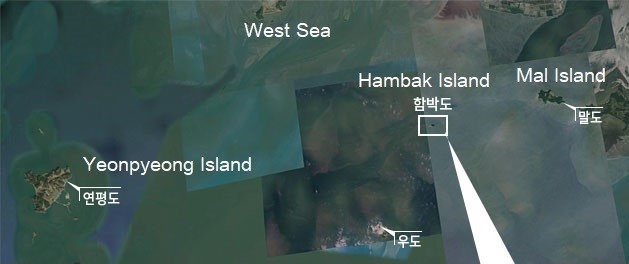
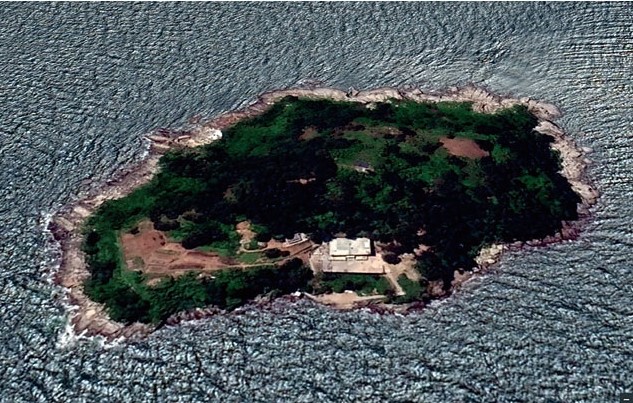
Until now, Hambakdo has been registered as “[ROK] National Forest Agency-owned State Land” in a copy of the real estate register, the Land Use Regulation Information Inquiry Service of the Ministry of Land, Infrastructure, and Transport, and the Management of Uninhabited Islands Catalog of Highly Visible Topography of the Ministry of Maritime Affairs and Fisheries. This topographic map records the latitude and longitude coordinates as 37°40’40” N and 126°01’41” E. It is an absurd situation in which the Ministry of Public Administration and Security, the Ministry of Maritime Affairs and Fisheries, and the Ministry of Land, Infrastructure, and Transport determined it to be “Republic of Korea territory,” while the Ministry of National Defense calls it “North Korean territory.” On top of this, now it is revealed that the North Korean military is stationed there.
[truncated] The Ministry of National Defense said, “the North Korean military is stationed on all of the islands in the West Sea near the NLL, except for the rocky and arid islands (Harindo, Ungdo, and Seokdo).” That means North Korean troops are stationed at a total of 20 islands near the NLL, including Hambakdo, Arido, and Daesooapdo. When asked when the occupation occurred and what size is the North Korean military stationed at Hambakdo, a senior official of the Ministry of National Defense said, “It is impossible to disclose because it is intelligence about North Korea.”
[Truncated] Furthermore, Hambak Island is an island adjacent to the West Sea NLL, one of the most sensitive military areas. At low tide, Hambak Island and Mal Island connect. Mal Island is where the [ROK] Marines and civilians live. In 1965, [North Korea] abducted 112 nearby residents to North Korea while they [the 112 ROK residents] were catching shellfish on the tidal flats surrounding Hambak Island.
Source: http://m.weekly.chosun.com/client/news/viw.asp?ctcd=C03&nNewsNumb=002567100000
Related Posts
-

-
-
 5.18 / Abuse of Authority / Censorship / Freedom of Expression / Freedom of Speech / Freedom of the Press / History / Human Rights / Lawfare / North Korea / South Korea / Suppression
South Korean Court Imprisons a Vietnam War Veteran and Retired ROK Army Colonel for Saying North Korea Was Involved in the Gwangju Uprising in May 1980
-
-
-